Nestled in the heart of Appalachia, you’ll find Red River Gorge (RRG). Eastern Kentucky’s natural wonder that keeps on giving. The land of arches. This place is not only a local favorite, but an amazing destination for visitors, especially day or weekend trips. In addition to the amazing hiking here, including both waterfalls and TONS of sandstone arches, RRG is one of the top climbing and rappelling destinations in the world! If canoeing or kayaking is more your speed, you can do that here too. RRG is a place we visit several times a year and we are never dissatisfied with our hikes. We will say, our favorite time of year is Fall or Winter when visiting.
RRG can make a fantastic day or weekend trip from several states surround Kentucky including Tennessee, West Virginia, North Carolina, Virginia, and Ohio.
Day trips from:
Lexington, KY- 57 mins
Louisville, KY 1 hr 53 mins
Knoxville, TN 2 hr 38 mins
Nashville, TN 3 hr 59 mins
Cincinnati Oh- 1 hr 55mins
Charleston, WV-2 hr 46 mins
Asheville, NC- 4 hr 56 mins
Rock Bridge Trail
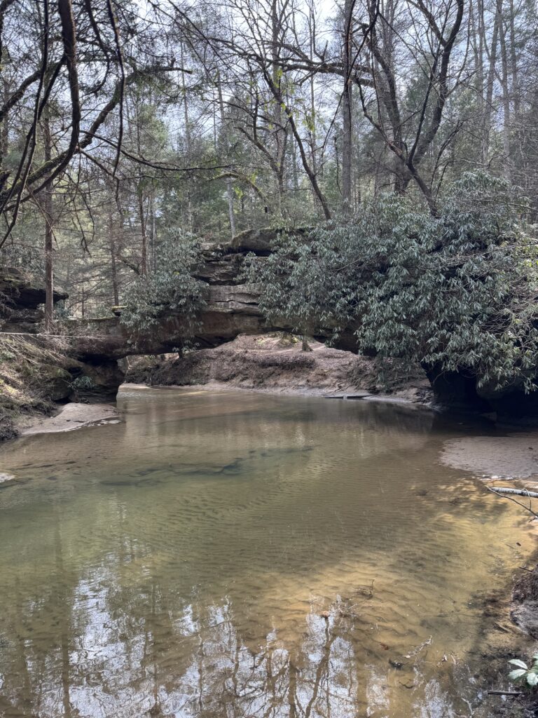
As noted, RRG is home to several sandstone arches, the most popular of which is Natural Bridge! If you haven’t hiked Natural Bridge, it is one to add to your RRG bucket list. Rock Bridge Trail offers a very unique sandstone arch as it was formed over a small creek. This is quite unique as out of all the sandstone arches in RRG, this is the only one over a body of water. Not only do you get a fantastic view of a sandstone arch but you also get to check out a small waterfall (Creation Falls) on the trail! We recently hiked Rock Bridge Trail and it’s ranking highly on our list of favorite trails in RRG.
The trail itself is a 1.5 mile loop trail that takes approximately one to two hours to complete. All Trails ranks it as moderate and we would have to agree with this assessment. On the back end of the trail, you will find yourself hiking up a long set of stairs which gives this hike a moderate rating. The elevation gain is 308 feet. Outside of the stairs, we would rate this an overall easy loop trail. Since this is a loop trail, we would recommend starting from the back to perhaps skip some of the difficulty of this trail. You will still find an elevation gain; however, it would not be nearly as difficult.
We spoke with some hikers on the trail that had missed Creation Falls. If you track your distance, you’ll find the waterfall after the rock bridge at approximately 0.7 miles into the hike. If you are hiking during a wet season, you will hear the waterfall as you approach. Located slightly off the path to the left, you’ll descend to a fenced overlook of the falls.
There are sections of the trail, particularly the beginning, that are paved, which is almost difficult to see due to foliage on the trail. Overall, you’re getting really great views for such a short hike!
Directions and Parking
Rock Bridge Trail is located near the Rock Bridge Picnic Area. We simply typed Rock Bridge Picnic Area into our GPS and easily found the trail. Once in the RRG area, you will drive to Rock Bridge Road which is a 3 miles gravel road that leads you directly to the trailhead. If you are like me with directions, you need landmarks to help guide you, haha! You will drive on the road between The Brick and Skybridge Service Station. The Rock Bridge Picnic area is where you will park.
One should consider that Rock Bridge Road can be closed due to weather conditions. There were a few trees that were down on the road which closed it to vehicles. Foot traffic is welcome, however! One should note that walking the gravel road will add 6 miles onto the hike making it 7.5 rather than 1.5 miles. Always note road closures if this is something that would deter you from hiking!
We hope this helps you plan your trip! As always, safe travels y’all! – Justin and Caitlin